 |
||
   |
||
|
MAIN GOALS SCIENTIFIC AND EPISTEMOLOGICAL GUIDELINES PROJECT DESCRIPTION RESEARCH TEAM PRODUCTS DATA BASES |
DATA BASES 1. Definition of information levels – compromise between tipification (key-words indexation) and transcription of integral texts or summaries. 2. Definition of the main tables: they should reflect the research grid of Hisportos: Geomorphologic conditionalisms/ Seaports interventions/ Central and local policies/ Entities and persons involved. 3. 3. Definition of key-words: indexing specialized languages, specific to each knowledge area. Technical glossaries of hydraulic engineering and geo-morphological concepts (tables Geomorphologic Phenomena and Technologies) DATA BASE STRUCTURE 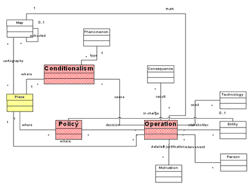 Data base was built in the assumption that all data are supposed to be linked in every field according criteria of interconnectivity. A. MAIN TABLES 1. CONDICIONALISMS – Data on geomorphologic, climatic and antropic conditionalisms of seaport interventions. 2. INTERVENTIONS – Data on all kinds of harbour construction or intervention, namely technical operations linked to polices condicionalisms, geomorphology and human agents. 3. POLICES – Data on central and/or local polices regarding seaports interventions. 4. MAPS – Technical description of historic cartography B. SECONDARY TABLES 1. GEOMORPHOLOGIC PHENOMENA and TECNOLOGIES. Meta-information: technical glossaries. 2. PERSONS and ENTITIES. – Biographic and institutional information C. REFERENCE TABLES 1. SOURCES 2. BIBLIOGRAPHY DATA BASE RESEARCH Requirements: user identification allows access to a username and password Research language: Portuguese Research options: 1. Queries guided by the main database and fields: - INTERVENTIONS - CONDITIONALISMS - TECHNICIENS - TECHNOLOGIES - GEOMORPHOLOGICAL PHENOMENA - POLICES - CARTOGRAPHY 2. Queries guided by keywords Potential users: Historians, geographers, architects, urban specialists, cartographers, engineers, environment specialists, territorial planning specialists, local authorities and tourism agents, as well as common people. |
|
||

